
Trace an Irving Street Directory Trail
An Irving street directory search works best as an address trail, not a claim about a whole block. First make sure the house number, direction, and street name are in the format used by the official address tools. Then keep the parcel or account number that appears with the result. That identifier is less likely to drift than a street label and helps distinguish one property from another when a subdivision, plat, or older deed uses a different description.
The result from one source should be labeled for what it is. DCAD identifies an appraisal owner or business name. A recorded deed identifies indexed parties to an instrument. A historic directory documents a dated listing. Dallas County voter status is a separate, protected context, and the inspected county lookup did not expose confirmed live fields. It returned HTTP 403 during research, so use the County Elections office and Texas Secretary of State guidance as the official alternatives rather than guessing at a roster.
- Normalize the address with the USPS ZIP guidance, then use DCAD's address route to locate the parcel record.
- Save the property address, account number, and legal description. Check the DCAD map for the parcel's mapped context and the available subdivision or neighborhood layers.
- Search the owner, prior indexed party, subdivision, document type, or a date range in the Dallas County deed portal. Read the index as an index until a copy is obtained.
- For a recorded plat or a zoning and subdivision question, compare Irving Planning's map and plan-copy route with the County Clerk record.
- For an older household lead, consult a dated city or telephone directory. The historical shelf is covered in more detail by the Irving city directory collections.
Note: Save the search date, source URL, and identifier because portal displays and street labels can change after a record is first found.
Irving Street Directory Search Fields
The Dallas Central Appraisal District address search is the first official stop for a current parcel tied to an Irving street. Its By Address form separates the address number from the street name. It also offers direction, building, suite, city, and optional From and To controls. The form calls for at least two characters in the street-name field, without spaces, and does not ask for a separate street-type field. If a short street name is the issue, DCAD documents `%` and the `X%` convention for a one-letter street.
| DCAD field | Input type | How it works |
|---|---|---|
| Address Number | Required entry | Starts the address query with the street name. |
| Street Name | Required entry | Use at least two characters and omit spaces. Street type is not a separate entry. |
| Direction and City | Selections | Use them when the address format needs narrowing. |
| Building, Suite, From, To | Optional controls | Useful for a unit or an address-range check. |
| Account Type | Selection | Residential, commercial, or BPP can narrow the result. |
The resulting appraisal display can show a property address, city, owner or business name, total value, and account type. It is not a current-residence list and does not replace the recorded instrument history. When an address returns nothing, test a spelling variant or a documented wildcard once, then record the parameters rather than treating the absence as proof.
Read an Irving Street on DCAD Map
The DCAD map viewer adds the mapped layer to an Irving street directory search. It can search by account, property address, owner name, subdivision or condominium, survey abstract, map grid, Dallas block, and neighborhood. Its tools include a legend, measurement controls, a locator, and map sharing. Search the street address first, identify the parcel, then use the parcel or account reference when moving to the deed index or a planning inquiry.
The DCAD map viewer shows the search and layer controls used for parcel context.
The map is a useful locator, but its help material says boundaries are approximate and do not replace a legal survey or the certified appraisal roll. DCAD also lists certified historic parcel-boundary products for 2022 through 2025. Those files can support a recent parcel comparison, but a parcel shape alone does not settle a boundary question.
Irving Planning offers another address route. Its interactive map can query an address, enable the subdivision layer, and reveal zoning, tax, and subdivision information after a property is selected. Planning can provide a plat when the subdivision name or index is known, while the County Clerk holds recorded plats. Irving does not provide individual-property surveys through this route.
Irving Street Records by Address
Several record sets can be attached to the same Irving address, but each answers a narrower question. Start with the appraisal layer for a parcel reference, use the map for context, then move to the recorded index for transfer instruments or plats. City material can supply zoning or permit-administration leads, yet the research did not confirm a public permit-search field set. For a municipal record that is not online, request an existing, specifically described record from the custodian rather than asking for a new address report.
| Address source | Custodian | What it can show | Available route |
|---|---|---|---|
| Appraisal account | Dallas Central Appraisal District | Property address, owner or business name, value, and account type | DCAD address search or map |
| Parcel map | DCAD | Mapped parcel, layers, subdivision, map-grid, and neighborhood context | Online viewer |
| Recorded deed or plat | Dallas County Clerk Recording Division | Indexed parties, instrument type, date, and legal or subdivision description | Online index, counter, mail request, or eligible e-certification |
| Subdivision and zoning | City of Irving Planning | Planning-map context and a route to known plats | Interactive map and plan-copy inquiry |
| Historic address listing | Dallas Public Library and archival collections | Dated household or street listing where a volume survives | Print, microfilm, reference, archive, or digitized volume |
Dallas County Elections is the proper custodian for voter-status information. The inspected lookup did not yield confirmed fields, and public status is not a full address database. The county office at 1520 Round Table Drive in Dallas and the Texas Secretary of State confidentiality guidance are the documented fallback channels. Do not copy protected voter data or infer participation beyond the source's stated scope.
Deed Chains Behind Irving Streets
The Dallas County deed and property portal is the recorded-instrument layer for an Irving street search. Quick Search and Advanced Search accept a grantor, grantee, subdivision, document type, document number, and date From and To controls. Search Index Only keeps the result closer to the index. Search Index and Full Text/OCR can broaden the result, but it can also produce unrelated text hits. A grantor is the party conveying an interest, while a grantee is the party receiving it.
The Dallas County deed index provides the recorded-party and date-range search controls.
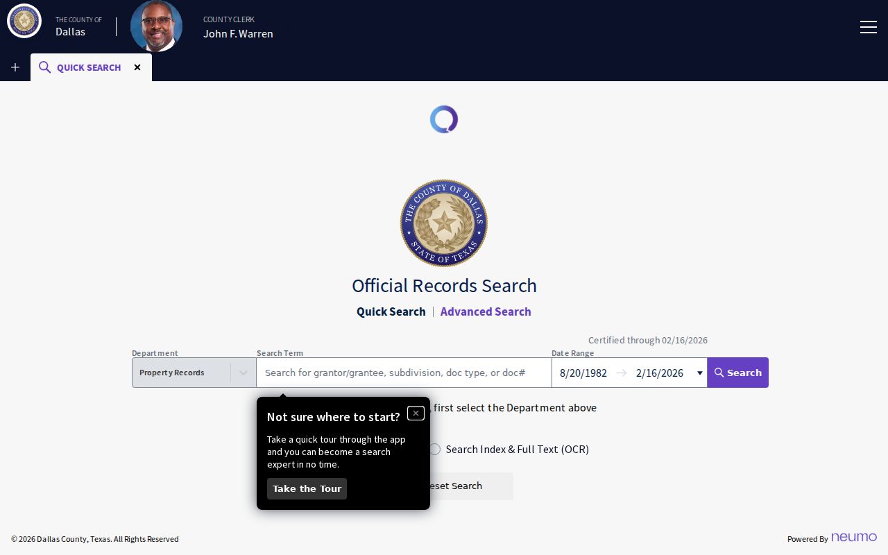
County Clerk information places digitized real-estate records online from 1846 to current. An online result still differs from a certified copy. For a copy, the Recording Division lists plain copies at $1 per page and certified copies at $1 per page plus $5 per document. Its document request form has fields for the recorded name, instrument number, document type, property address, copy choice, payment, and a prepaid return envelope.
The mail route goes to the Recording Division, Attn Index, 500 Elm Street, 2nd Floor, Dallas, TX 75202. The office also offers a counter, phone contact, eligible e-certification, and its online index. Personal checks are not accepted for the documented copy request. Note: Check the current Central Records notice before visiting because the April 2026 move can limit access to some year ranges.
Irving deed safety tip. Dallas County offers an official Property Alert enrollment route. A person following a parcel's recorded trail can separately request transaction alerts instead of repeatedly running name searches. Confirm the live enrollment terms before relying on the service.
Irving Street Plats and Descriptions
Street labels are useful, but a subdivision name, block and lot, or legal description can survive a later naming change. Compare the DCAD record with an Irving Planning map result and the recorded plat before deciding that two differently worded addresses are unrelated. The city planning applications and forms route includes a street-index lead and plat procedures, although the research did not capture the current index file's date or field structure.
- Parcel
- A mapped unit of property associated with an appraisal account. It is a locator, not a legal survey.
- Situs address
- The physical property address used in an appraisal or map context. It can differ from a mailing address.
- Plat
- A recorded map that lays out a subdivision, lots, blocks, easements, or dedications.
- Criss-cross directory
- A historical directory arranged by address or street, useful for a dated household search where the volume has that section.
County deeds and plats may retain former street names, subdivision wording, block and lot descriptions, easements, and dedications. That is why the best Irving street directory trail stores both the address and the legal description. If the records conflict, the County Clerk's recorded copy and a qualified survey professional, where appropriate, are better follow-up routes than a map screenshot.
For an existing municipal record that the map does not display, use Irving Open Records after identifying the likely custodian. The City Secretary directs requesters to check the Open Data Portal first and provides an online request route. A narrow request for a known plat, plan-copy, or permit-administration record is more likely to reach the right office than a request for a new street report.
Irving Street Directory Name Clues
Historic street names deserve their own search terms. The digitized 1937 directory page preserves Irving Avenue household entries and describes Irving Road from the Eagle Ford Road junction toward Irving. It also notes that IRWIN AV changed to Marburg and IRWIN DELL changed to Irwindell. Those are source-specific clues for a historical search, not proof of a citywide renumbering.
No official Irving-wide renumbering date or before-and-after address crosswalk was located in the research. Search the present and historic street terms together, then compare the deed legal description, recorded plat, DCAD description, and planning map. Dallas Public Library's history collections, historic directories, and map holdings provide a further check when a label changes between records.
Postal history needs the same care. Carl Range Station, associated with 75062, was discontinued in 2010, and the Downtown Classified Station associated with 75060 ended earlier. Those post-office changes do not prove that ZIP boundaries changed. Note: Treat a historic postal reference as a date clue, then verify a present address through USPS and the local parcel record.
Limits of an Irving Street Directory
An Irving street directory can connect an address to a parcel, an owner of record, a recorded instrument, a planning layer, or a dated historical listing. It cannot establish a current household from those facts alone. DCAD warns that its map is not the certified roll or a legal survey, and Dallas County cautions that online data can change or be supplied as-is. An empty search result means no hit under the terms and scope used, not that no record exists.
Texas public access also has firm limits. Protected voter residences, Social Security numbers, driver-license numbers, victim information, juvenile material, and other confidential fields are not material to collect or republish. Under the Texas Public Information Act, a request should identify an existing record held by the right custodian. It does not require an agency to build a new address list or answer a research question.
Lawful use. Use Irving address records for personal, lawful research such as family history, estate work, civic questions, or checking a property trail. Do not use them to stalk, harass, threaten, or harm anyone.